AA Landscape Urbanism 13-14_Delta Urbe_european atlas
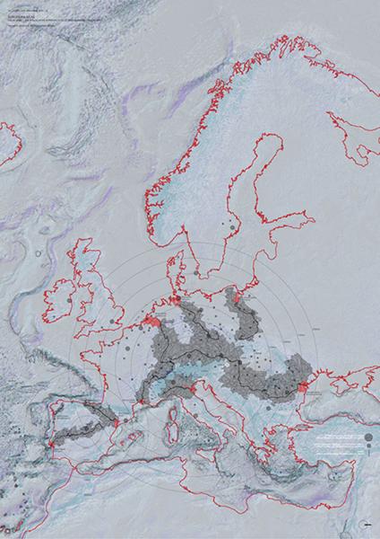
Atlas of European Deltas and the territories which affect them by the presence of urbanized areas or water management infrastructures, such as dams.
Deltas are rapidly changing environments that can be understood as manufactured landscapes, which are the consequence of a distant one that has been previously intervened. European rivers have experienced the effects of intense human activities along its courses, affecting the quantity of sediments flowing downstream where the deltas form through a continuous process of erosion and deposition of sediments. A territory of reciprocal landscapes is, thus, defined with the rivers running through them as the vehicles of transformation.
The Po Delta, in Italy, is one example of this continuous process of reshaping of the land. Through the concept of Land Reclamation its inhabitants have set the rules for its occupation by manipulating the balance between land and water. Today, one thing becomes clearly apparent: the delta is a heavily engineered territory. Throughout centuries of human struggle against water, it has undergone intensive projects that have secured the land and the people from floods. In consequence, the Po Delta has been frozen in time to its present day configuration.
The design project here presented rethinks the organization of the territory by accepting the potential within the changing nature of deltas. A new spatial organization can be achieved through the manipulation of the sediments transported by the river, and using the logics of traditional methods of Land Reclamation. The project itself, as deltas do, becomes an ever-changing machine that grows, recedes, and transforms creating new spatial intersections for potentially new social dynamics to occur in them.

Atlas of European Deltas and the territories which affect them by the presence of urbanized areas or water management infrastructures, such as dams.

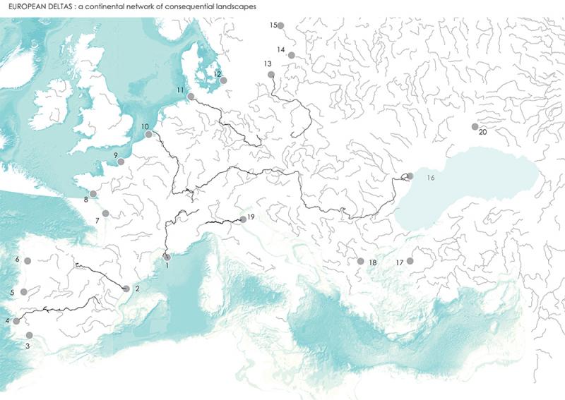
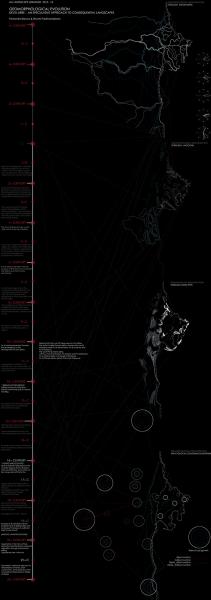
Map of European rivers and their tributaries. Highlighted are those which were included in the atlas of European Deltas.
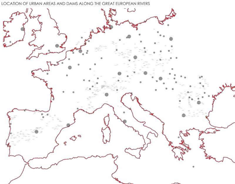
Map of the biggest urbanized areas and the location of river dams in the territories highlighted in the atlas of European Deltas.
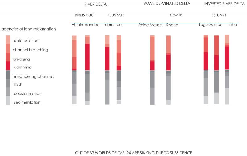
Description of the relation between different human activities happening along the course of rivers and the effect of deposition or erosion of sediments downstream that influence the formation of deltas.
Timeline describing the transformations of the Po Delta from four perspectives: variation on the course of the Po river, forward and backward movements of the coastline, sand dune activity, and foundation of urban settlements as land emerged from the water.
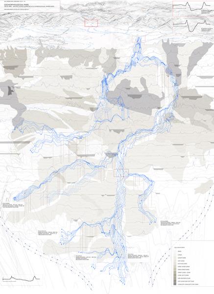
Description of the geomorphology conditions of the Po delta through vertical sections. The main characteristic of this landscapes is the particularity that the river runs higher than the surrounding land, channeled by natural levees formed by the accumulation of sediments as a consequence of floods.
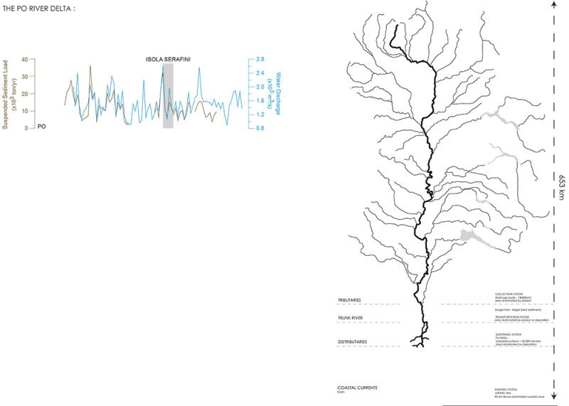
The Po River course explained in three sections based on the its tributary system. The first stage is at the river's origin in the mountains where it is heavily influenced by the streams that flow into it. The second stage is the trunk river, or length of the course without tributaries. Finally, the final stretch is the delta, where the river is influenced by the interaction with the sea water.
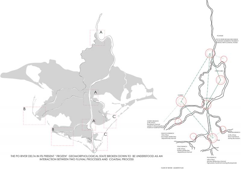
The Po River at its final stretch in the Delta. The presence of shallower lands and the interaction of the river with the coast provokes the branching of the main river. Sediments, then, are distributed in different proportions through the new waterways with the potential of forming land in different directions.
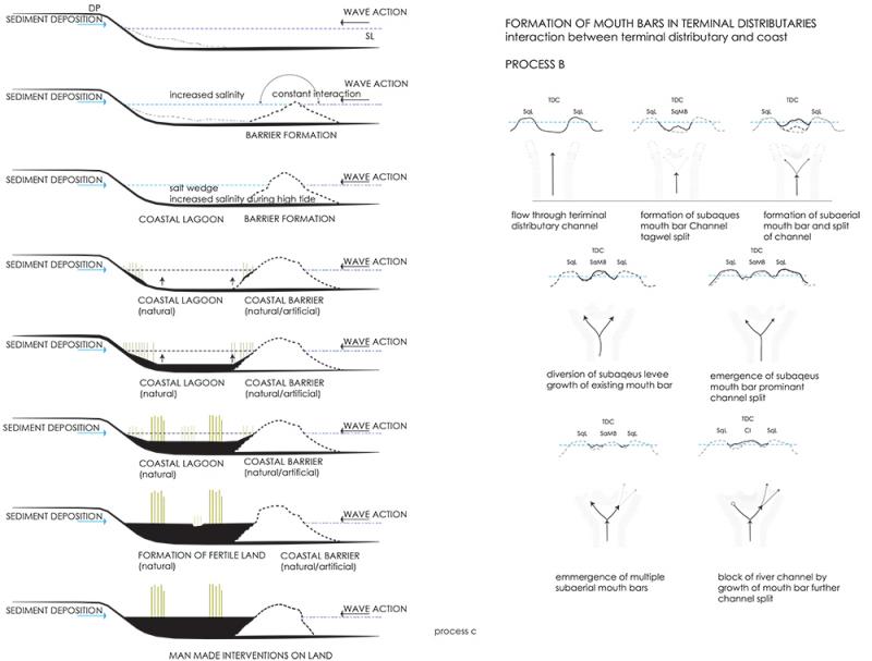
Series of sections describing the formation of deltas through the vertical deposition of sediments over the sea bed. On lesser slopes, sediments may accumulate in front of the river mouth, causing its obstruction and forcing the river to branch in new directions.
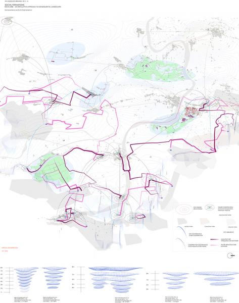
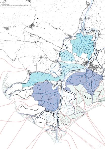
Description of the social dynamics taking place in the current Po Delta, and the conflicts that arouse when placed against other human or natural events occurring simultaneously. Specifically, the process of subsidence of the land, because of the artificial extraction of methane gas during the 1950's, increases the risk of flooding, which affect the practice of agriculture and demands great amounts of energy to protect. In contrast, aquaculture is a more profitable activity than the former, with a network of infrastructure established on the territory that could benefit from the potential flooded areas.
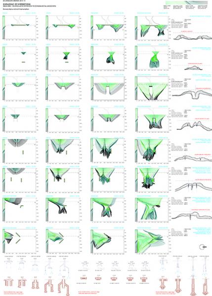
Catalog describing deltaic landforms and how their growth is informed by variations in the slope of the seabed and the density of the sediments. The formation of the new land can also be guided by specific interventions, like the introduction of obstacle in different angles or distances from the river mouths.
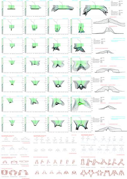
Continuation of the catalog described in the previous image.
First stage of the design proposal, indicating the principal areas to flood, based on those which are more affected by the process of subsidence. Inside these areas have also been highlighted the guidelines through which the sediments carried by the rivers are planned to be redirected to form the landforms described in the catalog.
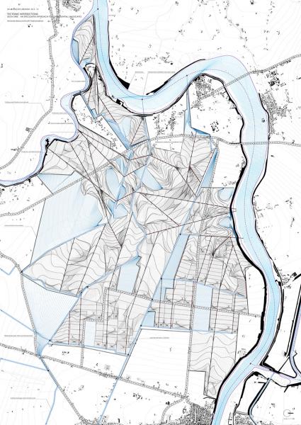
Detailed representation of the second stage of the design proposal, in which each of the flooded areas would be developed through the management of sediments. The formation of the new land is determined by the principles described in the catalog (deltaic formations), the logics of traditional Land Reclamation (colmata), and the presence of existing infrastructures, such as urban settlements, roads, and irrigation and drainage canals.
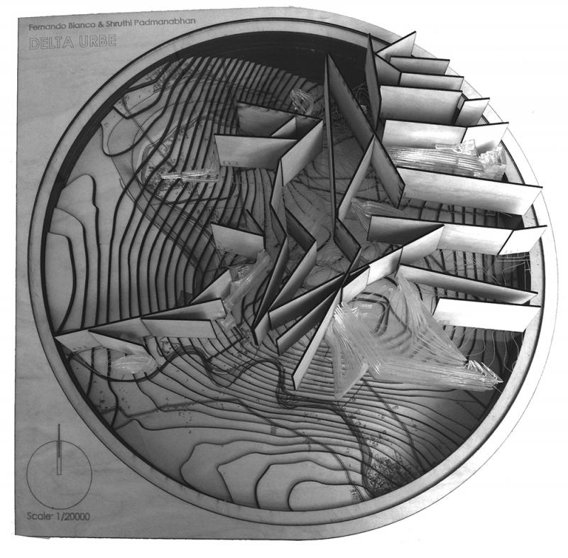
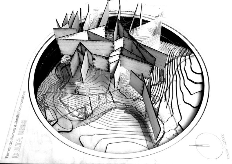
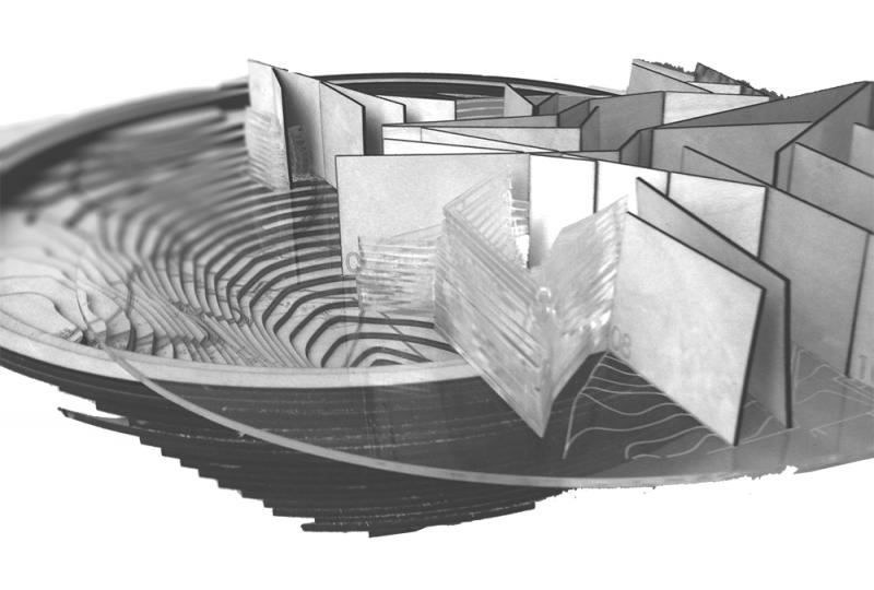
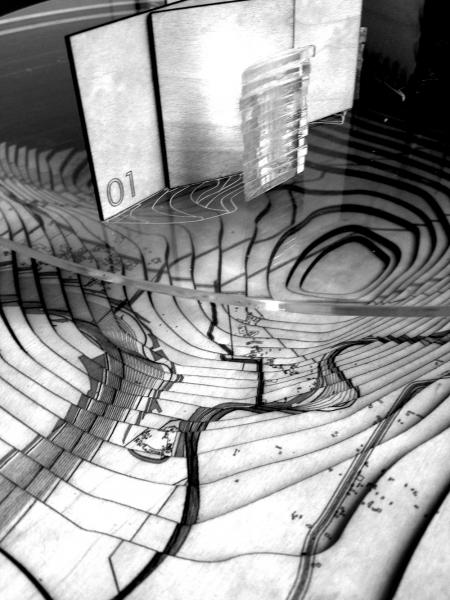
Physical model representing the subsiding topography as a base over which the design proposal will expand, here expressed through the network of guidelines from which the deltaic landforms will grow and with the inner lagoons left after the land has emerged from the water.
Physical model representing the subsiding topography as a base over which the design proposal will expand, here expressed through the network of guidelines from which the deltaic landforms will grow and with the inner lagoons left after the land has emerged from the water.
Physical model representing the subsiding topography as a base over which the design proposal will expand, here expressed through the network of guidelines from which the deltaic landforms will grow and with the inner lagoons left after the land has emerged from the water.
Physical model representing the subsiding topography as a base over which the design proposal will expand, here expressed through the network of guidelines from which the deltaic landforms will grow and with the inner lagoons left after the land has emerged from the water.